The desert shows you nothing; you must find everything.
al-Hamada(h) al-Hamra(h)
Sahara: Tenere: Tanzerouft, الصحراء
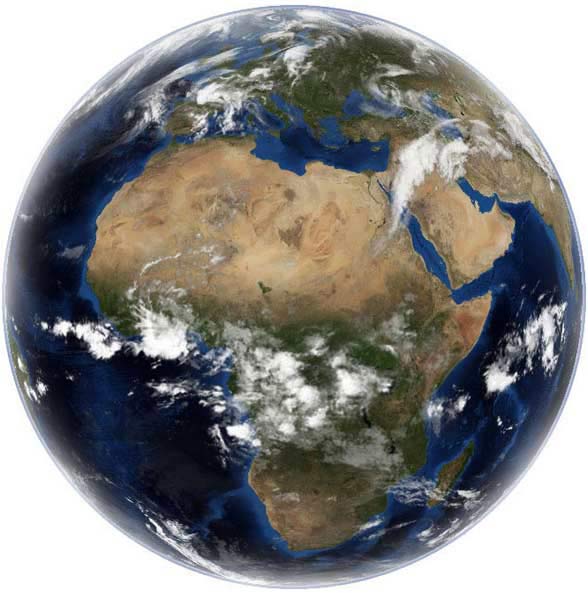
The awesome Sahara is the largest desert on the planet earth,
with an estimated size of between seven and nine million square kilometres (9,000,000
sq km). Its shortest distance from north to south is about 1000 miles. To imagine
the scale of this gigantic size, the Sahara occupies a third of Africa and is
as large as the continent of Europe. It is made of a number of smaller deserts
including the Libyan desert in Libya and Egypt, the Central Sahara in Libya and
Algeria (including the Ahoggar Mountains, the Tibesti Mountains, the Air Mountains,
and Tenere), and the Western Sahara; stretching across the whole of North Africa,
from the Red Sea to the Atlantic Ocean and from the Mediterranean to Chad and
the Sudan; with Tibesti's Emi Koussi being its highest peak (3,415 m/11,200 ft).
Courtesy of Nasa
terra incognita
The origin of The Sahara
Hundreds of millions of years ago the Sahara was covered by a great sea called
the Tethys Sea. Around 40 million years ago the tectonic plates gradually began
pushing Africa against Europe for 20 million years. Around 20 million years
ago Africa collided with Europe and closed the Tethys Sea. As Africa continued
to push against Europe northern Africa began to slowly emerge from the bottom
of the sea; leaving behind a tropical swamp. Eventually the swamps turned into
massive expanse of searing desert around 3 million years ago. See the following
documentary for detailed history.
40 Million Years Ago: The Tethys Sea.
This image is a screenshot from the following documentary.
Fascinating documentary about the Sahara when it was thriving
with marine life.
Around 800,000 years ago, the Sahara was hot, damp and covered with swamps
and vegetation everywhere. This period of heavy rain lasted for hundreds of
thousands of years; leaving behind wet and lush-green land, covered with rivers
and lakes, and teeming with hippopotami, rhinoceroses, crocodiles and elephants;
as well as three megalakes (giant lakes of fresh water): one lake was situated
in Tunisia (the tiny Chott el Djerid of today, the ancient Lake Tritonis);
the second megalake was in southern Libya (the Fezzan
lakes of today); and the third is the Chad megalake in Chad. According
to the Sahara Megalakes Project, Megafezzan is the only lake that provides
long term record of climate change in the central Sahara.
Ever since, the Sahara comes and goes just as ice ages do elsewhere. However,
according to an article published in the Independent Newspaper (September 8,
1999), titled: "Tilt of Earth's axis turned Sahara into a desert",
scientists have found that the Sahara was abruptly transformed from fertile
land into a desert after the Earth underwent one of its periodic changes in
orientation between 9000 and 6000 years ago; during which its tilt lessened
from 24.14 degrees off vertical to its present 23.45 degrees, and its closest
position to the sun gradually shifted from July to January.
The above documentary shows
the last cycle to have started around 5,500 years ago; after which the inhabitants
of the Sahara left to build the great civilisation of all times: the
Egyptian civilisation along the Nile. Scientists say 15,000 years from now
the tilt of the Earth will turn the Sahara green once more; and therefore each
dry-green cycle is around 20,000 years long.
Sahara Types
The Sahara is not a permanent feature of the landscape, but
is a continuously changing phenomenon that comes and goes just as ice ages do
across time. The last visit was about 5000 years ago, when the Sahara began its
current cycle after its lakes and rivers dried up into thin air. All it remained
are its prehistoric engravings, paintings and rock petroglyphs of extinct life,
and some of the lakes. (See Sahara
Wildlife page for more on these periods). Contrary to conception, only a
quarter of the Sahara is covered with sand and sand dunes, some of which are
nearly 200 metres high. Occasionally, sand dust from the Sahara has been carried
as far north as Germany and the United Kingdom, and as far west as the Americas.
The rest of the Sahara is mainly:
Mountains (25%) and dry valleys: like the Hoggar mountains in Algeria, Air
mountains in Niger, and Tibesti (also written as Tibisti) in Chad (with a small
section in Libya).
Rocks, stone plateaux and gravel plains.
Oases, like Ghadames and Ghat.
Sand Seas: sand with sparse vegetation: as in the Western Sahara, Libyan
Desert, Ubari Sand Sea, and Murzuk Sand Sea, and also found in mini rocky deserts,
like Acacus and al Hamada.
Definitions
Sarir: a flat sand plain, such as Tibesti or Tenere.
Idhan: a sand sea, like Idhan Murzuq and Idhan Awbari.
Erg or irq ( 3irq ): coarse or gravel plains (ergs),
like Tanezrouft.
Hamada: stone plateau, like the Red Hamada.
Jabal, jebel or djebel: mountain (in Arabic).
Tadrart, adrar: mountain (in Berber).
Adrar, adghagh: stone, rock (In Berber).
Wadi: dry valley.
Waw: from Waha (oasis: /Awasis/).
Aman: water (in Berber).
Sahara Eco-Regions
1- North Saharan: (1,675,300 square km): the far northern
part of the Sahara, just below the coasts of Egypt,
Libya, Algeria, Morocco. A midway point between the
Mediterranean climate and the Sahara proper.
3- Atlantic Coastal: (39,000 square km): along the Atlantic
coast, in the Western Sahara and Mauritania. Moisture
from the Atlantic Ocean sustains a small community
of plants.
4- West Saharan: (258,100 square km): Saharo-Mediterranean
climate, in Tassili n Ajjer, Air in Niger, Dhar Adrar
in Mauritanian, and Iforas Mountain in Mali and Algeria.
5- Saharan Halophytics: (54,000 square km): saline depressions
sustain salt-adapted plants, in Swia (in Egypt), and in the western Libyan
and southern Tunisian salt marshes and lakes.
6- Tanezrouft ('desert'):
dry and totally bare desert region, along the borders
of Mali, Niger and Algeria, just west of the Hoggar Mountains.
7- South Saharan: (1,101,700 square km): a narrow strip
between the central Sahara and southern sahel savanah. Summer
rain sustain some plants and grasses in Sudan, Chad,
Mali, Algeria, Mauritania.
8- South-South-East Saharan: Tibesti and Uwaynat Mountains
(82,200 square km): more rain and lower temperatures
sustain a family of trees and bushes including acacias,
palm trees, myrtles and Tamarix, in northern Chad,
southern Libya (by the Sudanese border).
Temperature In The Sahara
Winters in the subtropical north can be very cold where temperatures
can fall below freezing point, as opposed to the mild tropical
south, where rain falls more during the summer than it does
in the north. Similarly, temperatures are high during the
day and low at night. Although in the summer the temperature can
reach 50 degrees Celsius in the shade and in the winter can
reach -9 (minus nine), the average year round temperature
is about 30 degrees Celsius. Between the 27th of December and the 18th of January some area of the Sahara becomes covered with a thin white layer very similar to frost in Europe, which turns the surface white and hence the name: "The White Nights".
Wind In The Sahara
One of the main features of the wind in the Sahara is its ability to change
the surrounding landscape by shifting sand from one area to another; leading
to the formation of sand dunes on roads, where driving at night becomes very
dangerous. The worst time to visit the Sahara is between March and April largely
because of the wind: very windy almost every single day, especially near the
end of March and most of April. It is also common to see archaeological artifacts,
like flints, stone tools, pottery shreds and bones,
exposed by the wind and scattered
across the surface of the Sahara. These are part of Libya and the world's heritage
and history and therefore should be left where they are. Not doing so could lead
to prosecution.
The effects of the wind, exposing stones, flints,
and stone-age tools.
The Libyan Sahara
The Libyan Sahara can be further divided
into several smaller deserts or
regions. For convenience, Libya may be divided into three sections (from
top to bottom): the Western section
(starting from
the top and all the way down to Acacus); the Middle
section
(from Surt and all the way down to Sarir
Tibesti); and the Eastern section
(Cyrenaica and
the Libyan desert, all the way to Kufra and down
to the border with Sudan.
The Western Section
Al-Hamada al-Hamra (the
Red Plateau): a mixture of sand seas and rocky plains, immediately below the
Western Mountain and all the way down to Awbari Sand Sea and Wadi
Ash Shati. Often accessed via Daraj and Ghadames.
Idhan Ubari
(or Awbari Sand Sea): a sand desert of magnificent
sand dunes and desert lakes, starting from the Algerian border and
extending east to Sabha. Bordered from the south
by Hamadat Zigher (west) and Wadi al Hayat (the Valley
of Life), where a strip of oases and settlements cuts through
from Sabha to Awaynat near the Algerian border.
Ghat: immediately below Idhan Awbari: includes
three mountains: Acacus, and Messak Mellet & Messak Settafet, separated by
Wan Casa (a narrow strip of sand running along the
Acacus mountain from south to north). It is often
used to enter the Acacus Mountain either coming down
from Serdeles (Awaynat) or from Wadi Metkhandoush
via the Messak Settafet.
Idhan Murzuq (Murzuk Sand
Sea): immediately west of the Messak Millet and all the way east to Jabal Ghunaymah.
The Middle Section
The Pre-Desert: this term is generally
used to refer to the area before the desert
proper, just below Misrata and immediately to the
west of the Western Mountain, which includes sites
like Ghirza.
Sahara Surt (Surt Desert):
this mini desert is located below the Gulf of Surt
(Syrtis) and between Tripolitania and Cyrenaica,
which includes Waddan Mountain and the Black Mountain
(Asawda').
The Black Haruj Mountain: right at the centre of Libya,
with a summit of 1200 meters (Qaraf as Sabah), and
surrounded by a huge area of lava flow, which accounts
for its name. Accessed from Zillah (in the north)
via a track that cuts through the mountain all the
way south to Tmassah and Waw al-Kabir.
Sarir Tibesti: from Waw al Kabir
one can turn west and enter
Sarir as-Sabah and then Bin Ghunaymah mountain
(the site
of several Garamantean
and Stone Age discoveries); or continue south towards
Sarir Tibesti (which extends a bit into Chad) and
south-west towards Waw an-Namus.
Rebiana Sand Sea:
from Waw an-Namus one tracks east across the huge
Ramlat Rabyanah (Rebiana Sand Sea) towards Tazirbo (in the Eastern Section).
The Eastern Section
Marmarica (al-Butnan): a small desert area starting immediately
below the coast and between the Green Mountain and
the Egyptian border in Cyrenaica, and extends all
the way down to the great sand seas and Al Kufrah.
The Great
Sand Sea & Calanscio Sand Sea: these great sand seas
separate Cyrenaica from the Libyan desert proper
in the south and along the Egyptian border; with
various oases: Jaghbub (by the border), Awjilah,
Jalu, and various oil fields.
As-Sah'ra' al-Libiyyah
(the Libyan Sahara, also known as the
Libyan Desert
):
occupying much of south-east Libya and extends into
Egypt, which includes:
Rebiana Sand Sea (coming from Waw an-Namus), and
then Zighan, Buzaymah, Rebiana and al-Jawf; from
which one can either head north towards Jalu (via
a tarmac road), or track south towards Jebel Uweinat.
Jabal
al Uwaynat (Jebel Uweinat), close to
the Egyptian border: also the site of prehistoric
art.
The Languages Spoken in the Sahara
The main language spoken in the desert is Tamasheght or Tamazeght (Tamazight),
the Berber language of the nomadic Tuareg people, who inhabited the Sahara from
immemorial times. The Tuareg tribes are found in several countries
including Libya, Chad, Niger, Mali, Algeria, Burkina
Faso, northern Nigeria, Mauritania and the Western
Sahara. Other none-Tuareg Berber-speaking areas
include Siwa (in Egypt), Jalu and Awjilah (in Libya), and
other villages in southern Tunisia, Algeria and Morocco.
Other languages spoken in the Sahara include: Arabic
(of Egypt, Libya, Mauritania and the Western Sahara),
Beja (of the Red Sea), Nilo-Saharan (of the western
Sudan including the Fur of Darfur, and
the Tbawi of the Tebo of Libya), and the Saharan languages
(of Niger and Chad including Kanuri, Tedaga and Dazaga).
The Berber, Chadic and Arabic languages are members of
the Afro-Asiatic linguistic family (originally the Hamito-Semitic
Family), of North, Central and North-East Africa.
The
Red Sahara Desert
Alhamada Alhamra
Hammada al Hamada or Alhamadah al Hamra (or al Hamrah) means
The Red Plateau, probably in reference to its vibrant, ochry, red
colour. In contrast, other districts of the Sahara
are strictly golden, particularly with their calcite
specks shimmering like desert stars. The Red Hamada is a large area located in north-west Libya, at
the entrance to the great desert, coming from the
western mountain via Daraj, Ghadames and Qaryat. Hundreds
of meteorites smash onto her surface as far north as
Daraj. (See our Daraj page for a link to a list of Daraj meteorites). The red plateau
is a mixture of rocky terrains, mountains, valleys, tracks, sandy plains and
deserts; very popular among Sahara adventure travellers, who often
cross it from Daraj to Adiri via Awaynat
Wanin, and from there continue into the Awbari Sand Sea
towards the famous Fezzan lakes. After the lakes, one
briefly
returns to civilisation at Sabha, Awaynat and Germa -
the home of the ancient civilisation of the Berber Garamantes,
before venturing into:
Acacus.
Rocky Hamada.
The Golden Acacus
Entering The Golden Acacus.
Somehow one often hears about 'ancient places', like
ancient Egypt and the more recent ancient Rome,
but only in
Acacus
that one can actually feel "ancient".
You would instantly realise a new alien landscape, hidden
back in time and well isolated from the outside world.
Secrets of unknown civilisations and episodes of
human's distant history withstood the onslaught of
time in solitary caves for more that 12,000 years.
No visit to the desert
is complete without seeing Acacus.
Acacus Stone Formations.
Sphynx-like natural sculpture from Acacus.
The Black Sahara
Waw
an-Namus
volcano is located south-east of the Harouj Alaswad Mountain (The Black Harouj
Mountain), and not far from Tibesti Mountain by the Chadian border. The
volcanic field of Waw an-Namus is surrounded by an area of black deposit of ash,
between 10 and 20 kilometres wide, which accounts for its online nickname: the
Dark Spot, as it appeared in Google Earth.
The Green Sahara
Water Sources in the Sahara
The Sahara is green only where there is water, otherwise
it is white, beige, yellow, caramel,
gold, brown, red or black. Water sources in the desert
include several water wells, lakes, underground tables
and rain.
Water wells
in the
Acacus
desert are clearly marked on
the EWP Jebel Acacus map, like Aminanegh, Talwawat,
Sughd and Abankur, as well as several gheltas (or
water holes), in In Farden, Tin Lalen and Wadi Bubu.
Rain: average
rainfall: between 0 and 25 mm per annum; scarce but
brings the valleys back to life, and hence the name: the
Valley of Life in Fezzan.
Lakes: there
are several lakes in the desert, mostly in
the Awbari Sand Sea. These were part of, or left
over from, the ancient giant lake known as
Megafezzan
Lake.
The source of this water is usually a water table
under the surface of the desert, which intercepts
the land surface where the lakes are located.
There are huge water reserves under the Sahara,
just like oil, which the
Great Man Made River intercepts
to pump to the coastal towns and cities of
Libya - an idea which may had its origin in the
Garamantean "foggaras" - an ancient system of channels
used to channel the liquid-of-life from underground reserves to farms.
After rain, the dry valleys come to life again to sustain
some desert shrubs and bushes.
The Sahara Forest Project
Covering less than 1% of the world’s deserts with concentrating
solar power plants could produce 100% of the electricity
used in the whole world.
In addition to oil, gas, minerals and underground water
reserves, potential investors and governments have set their eyes on the Sahara
as a source of infinite energy. The staggering temperature degrees
apparently can turn the arid desert into
a gigantic storehouse of solar energy.
Environmentalists and critics have strongly objected
to the project being labeled
"green" and "natural", and argue that this kind of expensive
energy will not benefit the local poor populations of the Sahel, just
as most Europeans nowadays spend the harsh winter nights shivering with hope
because their low wages cannot match the staggering costs of energy bills. Others
even went on to say the project is a European ploy to deploy the Sahara to power
future Europe when oil becomes history.
While enthusiasts stress that current methods of supplying
arid regions with water, such as over-abstraction from underground reserves and
diverting water from other regions, are not
sustainable and could lead to conflict in the long
run.
As often is the case fact and fiction are not hard to obfuscate.
Covering less than 1% of the world’s deserts with
concentrating solar power plants could produce 100% of the electricity
used in the whole world.
Image from
exploration-architecture.com
The Sahara Forest Project
was first proposed at the third Claverton Energy
Group Conference, at Wessex Water
Plc headquarters, on April 13, 2008. The SFP was the brainchild
of Bill Watts, Charlie Paton and Michael Pawlyn.
The name "Sahara"
is used here to mean what the word 'Sahara'
means: namely 'desert', and therefore it includes any desert
in the world, although the focus point is the Sahara herself.
The project aims to provide a source of renewable energy,
food and water to desert regions around the world, by using
two technologies: Seawater Greenhouse technology (SG) and
Concentrated Solar Power (CSP). The former
creates
fresh water from seawater via especially designed
greenhouses, which also provide food-growing
environment;
while the latter
produces electricity from sunlight at a fraction of the
cost of photovoltaics, via special mirrors used to condense (or concentrate)
sunlight to create heat, which then is used to drive
conventional steam turbines to generate the needed electricity.
It was estimated that it will
cost around $59 billion to begin producing energy by 2020, and that
to start sending significant
amounts of energy from North Africa to Europe one needs to spend about
$465 billion over the
next 40 years. Hence, it does not come as a surprise when the French
President Nicolas Sarkozy proposed the construction of a new solar-power
station in the Sahara last year, when he founded the Mediterranean Union:
a strategic alliance of 43 countries from Europe, North Africa and the
Middle East.
Who knows, maybe North African countries will have
something more valuable in the future than the oil currently
their countries have but which they cannot enjoy. In contrast to
winter fuel-bills in Europe, only some lucky Libyans and Saharans can enjoy the
cool breeze of expensive air-conditions seen at the Rixos hotel - where the leaders
sit to decide the destiny of the impoverished population(s). It is not
a question of what the earth has to offer the country, as much as what the leaders
and their policies have to share with people.
Oil will certainly run out, and other sources of
energy must be found. The Sun is the best source of pure and clean
energy in our Solar System, as it is guaranteed to shine for
an estimated 5 billion more years - although the last two billion years
of its life will be far too-hot to sustain any form
of life but lava - just as it started its 10 billion years cycle.
Driving & Riding in The Desert
Sahara Sand Geyser ?
The locals in this video (youtube-nocookie.com/iGFwA14YfTg) seem puzzled
by the phenomenon. Some say it is a geyser, which usually occur only in
icy conditions or in lakes; while Wikipedia says it is "a
sand geyser or sand fountain", occurring in connection
with seismic events. Youtube users are saying it
could be a ruptured, pressurised gas pipe, while others say it is underground
water. There is another opinion saying it is to do with high
underground temperature, while some it is underground
cable running from Ashati to Sebha in southern Libya.
Resources
Online Sahara Journals & Articles
Sahara Journal: saharajournal.com/: Prehistory and History
of the Sahara: Scientific, international yearly journal. Articles in English,
Italian or French.
Journal of North African Studies: tandf.co.uk/journals/fnas
Volume 10, Number 3-4 / September-December 2005:
Special Issue: The Sahara: Past, Present and
Future:
“The climate-environment-society nexus in the Sahara from prehistoric
times to the present day”, pp. 253 - 292.
“ Incoming tourism, outgoing culture: Tourism,
development and cultural heritage in the Libyan Sahara”, pp. 441 - 457, Savino
Di Lernia.
“Garamantian agriculture and its significance in a wider North African context:
The evidence of the plant remains from the Fazzan project, pp. 397 - 412, Ruth
Pelling.
“Cultural heritage and conflict: The threatened archaeology of Western Sahara”,
pp. 413 - 439, Nick Brooks.
“Libya’s Saharan destiny”, pp. 605 - 617, George Joffé.
“Waging war on terror: The implications of America’s ‘New Imperialism’ for
Saharan peoples”, pp. 619 - 647, Jeremy Keenan.
“Looting the Sahara: The material, intellectual
and social implications of the destruction of cultural heritage” (briefing),
pp. 471 - 489, Jeremy Keenan.
Sahara Books
Sahara: The Extraordinary History of the World's Largest
Desert ,
by Marq de Villiers and Sheila Hirtle.
Hunters vs. pastoralists in the Sahara: material
culture and symbolic aspects, by Barich, Barbara E. Publication: Oxford: Archaeopress,
2005
Art of being Tuareg: Sahara nomads in a modern
world, by Seligman, Thomas K.; Loughran, Kristyne. Publication: Los Angeles : Iris
&
B. Gerald Cantor Center for Visual Arts at : UCLA Fowler Museum of
Cultural History, 2006
Men of salt: crossing the Sahara on the caravan
of white gold, by Benanav, Michael.
Publication: Guilford, Conn. : Lyons Press, 2006
Traditional medicine in Central Sahara : Pharmacopoeia
of Tassili N?ajjer, by Hammiche, H.
&
K. Maiza.
Journal of Etnopharmacology, Volume 105 (2006) pp. 358-367
Medicinal plants of the Sudan . Part 1 : Medicinal
plants of Erkowit.Medicinal and aromatic plants institute, by El Ghazali, G.
E. B. National council for research, Khartoum, 55 p., (Augustus 1986)
Medicinal plants of North Africa , Boulos, L.,
Reference Publications, Inc., 218 St. Clair River Drive, Box 344, Algonac, Michigan
48001, 286p. , (1983)