According to the Libyan Tourism Agency, the Acacus region
is less visited than the South Pole.
Libya has more
variety of
Saharan landscapes
than any other
North African
country; the
most impressive
of which are
Tadrart Acacus;
the world's
greatest sand
dunes of Murzuk
(Murzuq) and
Ubari Sand
Sea; the black
volcanic sands
of Waw an-Namous;
and the desert
lakes. The
name
Tadrart
Acacus,
pronounced /akakous/,
means
"Mountain-Acacus" and thus it is sometimes written as "Jabel
Acacus"
-
tadrart being a feminine Berber name for
"mountain"
(masculine:
adrar).
The site is a
world heritage
site, well known
for two things:
thousands of
prehistoric cave
paintings, dating
from 12000 BC
to 100 AD, and
its alien-like,
jagged landscape
of bizarre basalt
monoliths, towering
granite mountains
(the highest
point being 1506m),
endless wadis, and
mushroom-shaped
rock formations.
To see
some of the prehistoric wonders of Acacus please visit our Tashwinat art galleries.
Acacus
Tadrart Acacus is located down the southern-western
corner of Libya, bordering Algeria, and as such
it is part of Jabel Tassili (Tassili n'Ajjer);
with which it shares its history and culture.
Acacus is accessed from Awaynat
(north of the mountain), from Ghat
(west of the mountain), or it can be reached
from Tkerkiba or Germa via Wadi Metkhandoush
and then across the sand dunes of Wan
Casa into Akakous. The most popular entry route is Awaynat (Serdeles), via Adad then Awiss. The mountain chain is rich in various types of rocks
and unique features, including
sandstone and dark basalt mountains, with sand
dunes sweeping its high cliffs; most of which
had eroded away into hundreds of complex rock
formations and monoliths, overlooking
sand rivers and endless wadis, zigzagging their
way through this bizarre region of the great
Sahara desert.
This deserted desert region is the home of
the most important open-air galleries of prehistoric
rock art in the world, many of which are more
than 12000 years old. The art is far from catalogued
and studied and therefore provides a unique opportunity
for real adventure travellers to explore and
discover its hidden secrets and long forgotten
past. It is also the home of the Berber Tuareg
people, who sadly began, after all these thousands
of years, to move away from their native habitat
to the nearby centres, camps and oases.
The remaining few Tuareg families who failed
to let go have now been targeted by some
tourists as one of the main attractions of the
region. To the dignified Hoggar such degrading
environment signals the beginning of the end
of an historical saga, and the beginning
of a new era, namely that of tourism and development!
For these reasons environmentally-concerned and responsible
travel organisations and companies call for all tourists and travellers
to respect and help the local communities with
whatever they can in order for these local communities
to survive and feel at home.
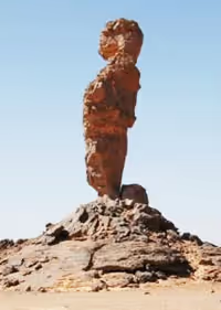
Adad: the name Adad means 'finger' or 'thumb' in Berber language, from the fact that the stone resemble the shape of a finger (see above). Coming down from Awaynat you will see this site, before you enter Awiss.
Awiss: Awiss is a general name for the northern region of Acacus Mountain(s), namely for the area after Adad and before Tashwinat. The southern part of the region is known as Tadrart Acacus.
Wadi Tashwinat (Tashweenat): the
Capital of Acacus. Wadi Tashwinat (or
Tashweenat) is one of the main wadis
of the Acacus region, with high cliffs
surrounding the area, about 60 kilometres long, with
numerous art sites at the bottom of the rock formations,
and with several side wadis branching
off towards more formations and prehistoric
cave
treasures. It was said that there are
at least 101 wadis in Wadi Tashwinat. Its intricate network
of caves, which provided shelter for prehistoric people
for thousands of years, is the home of thousands of drawings
and engravings, telling various stories
about the desert's primeval past. (See our art galleries
for more on art from this wadi.)
Wadi
Tanshalt: fantastic
panoramic views over the Acacus, and some of the
best rock art in the southern parts of Acacus. Scenes
of cows, stylised human figures, and ancient Tuareg Tifinagh inscriptions.
Wadi Anshal: elephant and giraffe engravings,
and paintings of women.
Wadi In Ferdan: hunting scenes of humans carrying
bows and arrows in pursuit of animals. A camel-shaped
rock formation.
Tin Khilqa (Tin Halega): (see below).
Forzhaga Arch: giant natural arch (see below).
Wan Kaza (Wan Casa): a north-south chain of golden multicoloured
sand dunes, running down along the eastern edge of the Acacus mountains.
Pre-Holocene deposits indicate
wet phases of the Pleistocene, with early Paleolithic
artifacts, organic lake deposits and fossils mostly
associated with Acheulean artifacts. The molluscs and
the fragments of ostrich eggs were dated to about 7000
BP. Also several fossilized remains of large mammals
and reptiles have been found in the area.
Tin Halega Natural Arch, Acacus.
Tin Khilqa: fine three-columned natural rock
arch, made of soft sand stone. Also written as,
Tin Khaleqa, Tin Khlega, Tin Halega, or Tin Ghalaga.
Tin Ghalega (Ghalaga) Natural Rock Arch, Acacus.
Tan Loubbou Arch, also known as Tin Lebbo or In Allabu (in some maps).
Tin Lebbo
The Natural Arch (Forzhaga), Acacus.
The big arch, also known as: Afozdjar, Afozedzhar, Afozedhar,
Fozzigiaren, Afozzigiar, or Forzhaga Arch
(Arco di Forzhaga). The giant stone gateway, located on the junction
of three wadis, is the most impressive of Acacus' rock formations. Some
of the prehistoric images of
the human figures found around this area are
strikingly modern in style.
Entering Tadrart Acacus
The main point of entry to Acacus is from Awaynat, which
is also known by its Berber name Serdeles. The northern part of the mountain
is known as Awiss, and the southern part as Tadrart Acacus.
Many of Acacus' hidden wadis can be reached from here. Some
regions require trekking, either on foot or on camels.
Awaynat - Acacus:
Sabha - Germa - Ubari - Awaynat - Adad - Awiss - Tin Lallen - Talwawt - Wadi Tashwinat - the home of more than 100 valleys.
Ghat - Acacus:
Ghat is too close to the Algerian border and therefore we always recommend entering Acacus via Awaynat. However, the main routes from Ghat and Tanezuft are:
Ghat > -al-Fawar (Wadi Tanezuft)
> Wadi Adar n Dzhalko
> Tissatin.
Ghat > Wadi Tanezuft
> Wadi In Aghallasham
> Tihe n Awiss Pass
> Awiss.
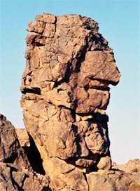
A view of Acacus Mountain.
Water Sites
Regular supply of water: Bir Aminaner or Mninegh (borehole, in Wadi
Aminaner), Bir Talwawat (borehole), Bir Sughd
(well), Bir Abankur (in Wadi Tanezuft, coming down from Wadi
Tasbet).
Bir Aminaner (Mninegh, or Aminanegh: with emphatic /r/).
Aminaner well: water point for traveller and locals: GPS location
:( N 24 51'
34.21"
E 10 39'
38.59"
). Some visitors pump water out and use it to
shower. We recommend to reserve water for future generations
by using it only for bare essentials.
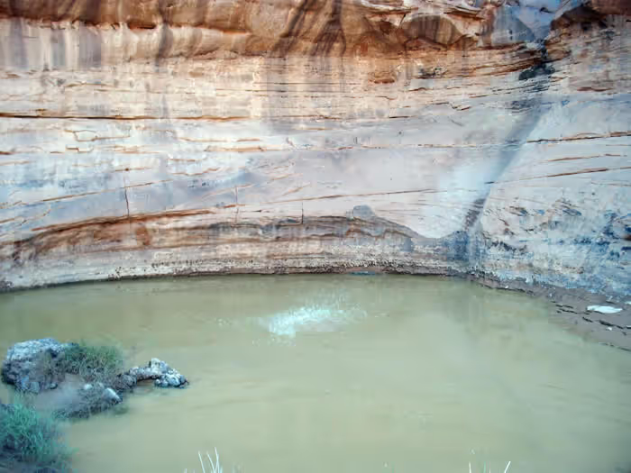
Gheltas: these are holes in
wadi floors; some are easily
accessible, like the one south of In Farden in Wadi Tashwinat,
while others require a rope and a bucket.
Other gheltas include one at Tin Lalen, and another
one farther south near Wadi Bubu (not far from the border).
Wadi Tashwinat Gelta.
Acacus-Related Links
Unesco
World Heritage
: Rock-Art Sites of Tadrart
Acacus:
http://whc.unesco.org/en/list/287
Italian-Libyan-Archaeological
Mission in the Acacus and Messak:
http://www.acacus.org
University College London: Transitions
To Farming In The Sahara: the Prehistoric Society's 2002
Study Tour of Libya's Fezzan
www.ucl.ac.uk/prehistoric/past/past42.html
In the
Valley of Life, oil is death to the art of a
lost civilisation:
Hammers threaten rock
carvings that show a corner of the Sahara
was not always a desert. By John Bohannon:
http://www.guardian.co.uk/artanddesign/2005/feb/10/heritage.artsandhumanities


.avif)
-tashwinat.avif)